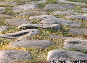
52.6km of Hell in 111th edition of the Queen of the Classics
 Following reconnaissance by race director Christian Prudhomme and technical director Jean-François Pescheux, organiser ASO has officially rated the 27 sectors of cobbles to be crossed in Sunday’s Paris-Roubaix. Each has been graded according to length and unevenness, and been awarded a star-rating between one and five.
The 2013 race peloton will have to traverse a total of 52.6km cobbles, out of a total of 254km, with the longest sectors – in Quiévy and at Hornaing – at 3.7km, and the shortest – in Roubaix shortly before the entrance to the velodrome – at just 300 metres. Three of the cobbled sectors have been designated the maximum of five stars, starting at the mythical 2.4km long Trouée d’Arenberg, which comes after 158km – 14km earlier than in 2012 – with the others at Mons-en-Pévèle after 205km, and at Le Carrefour de l’Arbre after 236.5km.
The only one deemed easy enough to warrant one star is that final 300 metre sector on Espace Charles Crupelandt – named after the local rider that won the 1912 and 1914 editions of the race – also known as the Chemin des Géants, which was laid in 1996 to commemorate the race’s centenary.
The 2012 edition will also see the welcome return of the famous sector between Wallers and Hélesmes, which passes through a disused railway embankment, under a bridge with no top known as “Pont Gibus”, named after French two-time winner Gilbert Duclos-Lassalle. The sector was removed from the race five years ago after its surface had deteriorated too far, but makes its return after extensive repairs by local volunteers and collages.
Restoration work has also meant that the 3.7km Hornaing cobbles have made their return; the sector was crossed in the opposite direction in stage 3 of the 2010 Tour de France, where yellow jersey Sylvain Chavanel suffered the puncture that cost him the race lead.
The 27 cobbled sectors of Paris–Roubaix
27. Troisvilles (km 98.5 – 2,200 m) ***
26. Viesly (km 105 – 1,800 m) ***
25. Quiévy (km 107.5 – 3700 m) ****
24. Saint-Python (km 112.5 – 1,500 m) **
23. Vertain (km 120 – 2,300 m) ***
22. Verchain-Maugré (km 130 – 1,600 m) ***
21. Quérénaing – Maing (km 133 – 2,500 m) ***
20. Monchaux-sur-Ecaillon (km 136.5 – 1,600 m) ***
19. Haveluy (km 149.5 – 2,500 m) ****
18. Trouée d’Arenberg (km 158 – 2,400 m) *****
17. Wallers – Hélesmes, aka “Pont Gibus” (km 164 – 1,600 m) ***
16. Hornaing (km 170.5 – 3,700 m) ****
15. Warlaing – Brillon (km 178 – 2,400 m)
14. Tilloy – Sars-et-Rosières (km 181.5 – 2,400 m) ***
13. Beuvry-la-Forêt – Orchies (km 188 – 1,400m) ***
12. Orchies (km 193 – 1,700 m) ***
11. Auchy-lez-Orchies – Bersée (km 199 – 2,600 m) ***
10. Mons-en-Pévèle (km 205 – 3,000 m) *****
9. Mérignies – Avelin (km 211 – 700 m) **
8. Pont-Thibaut (km 214.5 – 1,400 m) ***
7. Templeuve – Moulin de Vertain (km 220.5 – 500 m) **
6. Cysoing – Bourghelles (km 227 – 1,300 m) ***
Bourghelles – Wannehain (km 229.5 – 1,100 m) ***
5. Camphin-en-Pévèle (km 234 – 1,800 m) ****
4. Le Carrefour de l’Arbre (km 236.5 – 2,100 m) *****
3. Gruson (km 239 – 1,100 m) **
2. Hem (km 246 – 1,400 m) **
1. Roubaix (km 256.5 – 300 m) *